
When Learning is Fun!

gryphon.malta
104, Triq is-Sedqa,
Attard ATD 2315
Malta
Tel: +356 7961 7858 | +356 7941 7401 | +356 2141 7401
E-mail: info@gryphonmalta.com
VAT: MT 1668-9122

Your Cart
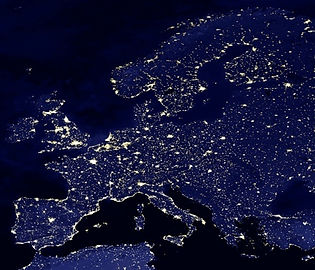
World Map by Day and by Night
Back to Innovative 3D Material Menu
Back to OnLine Shop
Back to Teachers' Resources
Flip-image maps show you two states in one picture, in this case the world's Continents by day and by night.
The flip-image from daytime to night-time can be observed on the map by moving slightly from left to right or vice-versa.
This innovative learning product will promote understanding through visual interaction. A number of schools have reported that both pupils and teachers are enthusiastic about the potential of such maps for modern geography lessons since pupils are engaged and show personal involvement in their learning.

Effect: Flip Image
Map dimensions: 67.5 cm x 40 cm.
What can one learn from this world map?
This innovative teaching product will assist teachers to explain a number of study areas, which among others include:
Continents’ names, sizes and relative positions in the world;
Areas in continents covered by a high concentration of vegetation or desert, and their relative share to the size of the whole continent;
Names of the oceans and their relative location to the continents;
Deduce the depths of oceans depending on the colour shade – the darker the area, the deeper the ocean;
Positions of continental planes, rises and ridges;
Parts of the world that are covered by ice and their relative coverage share to the continent;
Viewing the map by night, one can deduce:
the level of industrialisation of a continent or a particular country by observing the level of light concentration during night time; and
how the world looks from space during night-time and the level of light pollution in each relative country or continent.
Back to Innovative 3D Material Menu
Back to OnLine Shop
Back to Teachers' Resources